20thcentury urban planning changed the character of Glasgow and other British cities.
 |
|
A Glasgow shipyard in 1944, courtesy of Ministry of Information Second World War Official Collection.
|
The area along the Clyde should have been the oldest part of Glasgow, but the section I walked was a montage of tower blocks and industrial wasteland. The M8 cuts straight through the city with total disregard for the neighborhoods it slices. At the river, a new mixed-used development houses the Sunday Mail. It is bounded by empty lots. Along the water, attempts have been made to create public spaces, but they’re of the concrete-block variety.
No bombs created this; it’s the result of 20thcentury urban planning. I know the look; it’s shared by my hometown of Buffalo. I don’t tarry in these places. We headed back to Glasgow’s city center.
 |
|
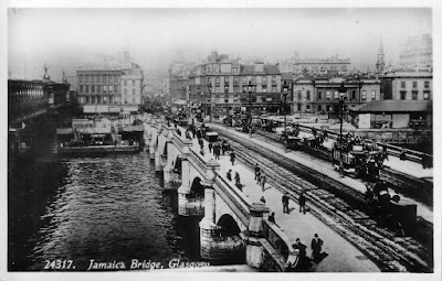
The Jamaica Street bridge area, in its 19th century grandeur.
|
Victorian Glasgow was known as “the second city of the Empire.” Its growth was based on industry: cotton, textiles, chemicals, glass, paper and soap. In time, heavy industry like shipbuilding, steel and locomotives also thrived. Immigrants from the Highlands in the 1820s and Ireland in the 1840s formed the backbone of Glasgow’s workforce.
Glasgow was wealthy. But its splendid mansions stood in contrast to areas where poverty, disease and crime reigned. Until the development of the Loch Katrine water scheme in 1859, typhus, cholera and other water-borne diseases stalked the poor. The opening of this water system sparked a plan of improvement. Municipal gas supplies, public lighting, electric tramways, free school meals, parks and libraries all raised the quality of life.
 |
| The same area, today. |
Glasgow’s population grew rapidly in the 19th and 20th centuries, reaching a peak of 1.1 million people in 1938. Clydeside shipyards were the largest in the world before WW1. They expanded dramatically during the war. But in the interwar period, world demand for great ships was down. The yards proved too big, expensive, and inefficient. The shipyards began a long period of decline. By the 1960s, manufacturing jobs were mostly gone.
As we did here in America, Glasgow responded with slum clearance. But the British solution involved moving people completely out of the city, to designated new towns such as Glenrothes, Irvine, East Kilbride, Cumbernauld and Livingston. They then reduced the size of the city’s borders. This intentional depopulation reduced the City of Glasgow council area to about 615,070.
 |
|
A small drying green amid Calton backcourt slum, c. 1900, courtesy Glasgow City Council, Glasgow Museums.
|
The New Towns Act of 1946was the cornerstone of a ‘New Jerusalem’ promised by the Labour Party at the end of WW2. These towns were in some ways equivalent to American suburbs, but they were public corporations financed by the government. Their boards were appointed by the central government, rather than selected by voters. They had planning and compulsory purchase order powers.
Towns had to have a population of at least 60,000 people, include a balance of housing and jobs, and—most importantly—be single family homes of low density. For someone living in an urban tenement, this had to sound heavenly.
 |
|
St Mungo’s Church, Cumbernauld, J. Pugh, courtesy University of St. Andrews
|
Above all, they were not be divided by class. That part didn’t work. By the 1960s they were overwhelmingly working-class. Poorer families were excluded by high rents. The middle classes didn’t like the overwhelmingly proletarian character of Brutalist architecture.
That mid-century concrete makes us Americans avoid the New Towns when we visit Britain. We have enough of it at home. But the idea still has resonance for our British cousins. As recently as 2015, the government was proposing smaller eco-New Towns.
