fbpx

Goodbye, Alaska Highway!

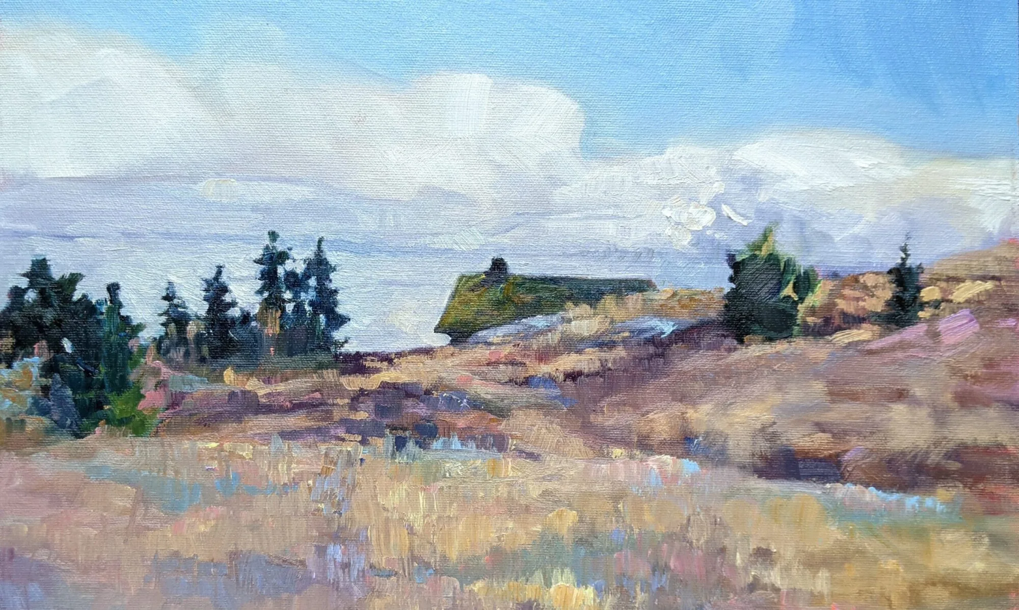
"Regrowth and regeneration," (Borrow Pit #4), by Carol L. Douglas

“Regrowth and regeneration,” (Borrow Pit #4), by Carol L. Douglas
Last summer it took us eight days to drive to Alaska in this vehicle. Given our detours and painting stops, doubling the time this year seemed a fair estimate.
Instead, we left the Alaska Highway at 4 PM yesterday.
East of Fort Nelson, Mary and I had to admit that not much looked familiar. True, we’d passed through here a month earlier last year. In fact, this was the same area in which we’d been stopped for hours due to an accident. But, no, we remembered nothing.
Getting out of here, even in 4WD, was tough. A sharp rise and a lip before we hit the road tore our tailpipe off.

Getting out of here, even in 4WD, was tough. A sharp rise tore our tailpipe loose.
Last year, this stretch seemed so desolate. Yesterday, it seemed sedate and settled. The Al-Can looks very different going west to east. Last year, we counted off the signs of civilization as we lost them: regular gasoline, rest stops, power lines, restaurants, and other travelers, until all that was left was us and the open road. This year, those same amenities crowd back into our vision like not-particularly-welcome relatives. I’ll be happy to be in my snug Maine house again, but I do like the solitude.
The Kiskatinaw Bridge is a three span, timber truss structure built in 1942 by the Corps of Engineers. It's still used today, and its maintenance must be a pip.

The Kiskatinaw Bridge is a curving, three-span, timber truss structure built in 1942 by the Corps of Engineers. It’s still in use today, and its maintenance must be a pip.
One great difference this year has been pavement. It’s mostly past construction season. There are not many sections gravier signs left to remind Mary of poutine. However, the fact that she could joke about poutine is a good sign, for it signals the return of some appetite, even though she still remains pretty low.
About 100 km east of Fort Nelson, I pulled down an off-road track to paint some regrowth in a wildfire area. This is a subject I’d like to return to, since the geometry and variety are so fascinating. But I never relaxed while doing the painting. Plein air painters know this feeling of unease. For me it’s very rare, so when it happens, I heed it. After all, I was standing in a black bear’s salad bowl. So this was a rushed effort, and I’ll detail it in the studio.
There are a few paintings that “got away” along the Al-Can. One was of a hunting camp along the highway. I’d hoped to find one on this last day to paint. I also wanted to paint something of the Peace River Valley, for it looks so western here in its deeply cut ravine.
Goodbye, Alaska Highway!

Goodbye, Alaska Highway!
Alas, the Al-Can carries much more traffic near its eastern terminus. There’s gas exploration, agriculture, and much logging. The shoulder is narrow and the lay-bys few and far between. I took a few tracks off the main road, and came up with nothing. That seemed ironic, since most of the trip has been filled with stunning vistas at every turn.
“It’s an early bedtime, then,” I told myself, and pushed on to our destination. There, Mary pointed out that I’d knocked the tailpipe off while off-road. So once again this morning will be spent in a muffler shop and we’ll be that much little bit more delayed.
I remind myself that we’ve just passed through more than a thousand miles of territory where there are no muffler shops. We have a choice of four here in Dawson Creek. My irritation melts into gratitude to a providential God.
On the edge of civilization

"McDonald Creek," by Carol L. Douglas

“McDonald Creek,” by Carol L. Douglas
I’ve seen Mary’s headache, malaise, and swollen neck before. Her older sister had mononucleosis in college and looked and acted the same way. When Mary’s tonsils started to swell, I decided to make quick time to a medical clinic at Ft. Nelson, BC.
Three minutes and $70 later, Mary exited with a scrip for penicillin. No blood tests, no swabs; the doctor took a quick look in her mouth and announced it was tonsillitis. Penicillin won’t hurt the girl and might actually help, so we had it filled. Mono is untreatable anyway.
Mary took a nap in the sun while I painted.

Mary took a nap in the sun while I painted.
My husband asked why I didn’t see the doctor myself, since I’m still hacking. I just have a cold, I answered. For less than the cost of penicillin, I can rinse my mouth with Alberta rye whiskey. If it doesn’t cure me, at least I won’t mind so much.
Fort Nelson is on the east slope of the Rockies. It seems positively cosmopolitan compared to where we’ve been. Some women have tri-colored highlights in their hair, all in the same gingery tones. That, I presume, implies a beautician in town. There is clothing other than camouflage, although the Super 8 where we’re staying does have a sign asking visitors to remove their muddy boots.
Trail riders are a common site in northern British Columbia.

Trail riders are a common site in northern British Columbia.
Hayfields and buildings appear sporadically along the road into town. The tree cover looks more familiar to my eastern eyes. Mixed forests of predominantly deciduous trees cover the lower slopes.
Today we will follow the Alaska Highway to its starting point at Dawson Creek. This will take us down into the prairie land of Peace River Country. This area was explored during Sir Alexander MacKenzie’s journeys of 1789 and 1792-3. The latter was the first east-west crossing of North America north of Mexico, preceding the Lewis and Clark expedition by 10 years.
Like so many great American explorers, MacKenzie’s goal was to find a water route across the continent—the fabled Northwest Passage that beguiled the Vikings, Cortés, Sir Francis Drake, John Cabot, Henry Hudson, LaSalle, and so many others. MacKenzie, however, managed to reach all three great oceans that surround Canada, and his explorations took him on the longest possible route, for the continent grows wider as it goes north.
My main companions yesterday were bears, not hoofed things. It's almost time to hibernate.

My main companions yesterday were bears, not hoofed things. It’s almost time to hibernate.
Our prairie time will be briefly interrupted with a slight detour into Banff and Jasper National Parks this weekend. After that, I’m hoping to make better time. A flatter road will be nicer on the old hooptie, which seems to have sprung another exhaust leak. Poor old thing. I’m not sure who’s suffering more, the car or Mary. I’ll push the liquids at both of them.

Twice told tales

"Avalanche Country," oil on canvas by Carol L. Douglas.

“Avalanche Country,” oil on canvas by Carol L. Douglas.
Mary is flat on her back, ill with something I cannot figure out. I have a nasty cold; she has that and something else. I left her sleeping in a room at the Toad River Lodge and headed back to Muncho Lake to paint.
Northwest Canada and Alaska rivers and lakes are often strangely-colored—milk chocolate brown, ivory, or turquoise. This is caused by rock flour, which is a substance of fine-grained particles of rock ground off bedrock by glacial erosion. Because the silt is so fine, it ends up suspended in glacial meltwater, creating cloudy water sometimes called glacial milk.
These fellows came to visit me while I was painting. When they realized there was a human involved, they skedaddled. There was a foal with them, who stayed carefully behind. I'm ashamed to say I have no idea what species they are.

These fellows came to visit me while I was painting. When they realized there was a human involved, they skedaddled. There was a baby with them, who stayed carefully behind. I’m ashamed to say I have no idea what species they are.
Lake Louise in Alberta is the most famous of these rock flour lakes, but they occur anywhere there’s glaciation. West of Toad River there are great dumps of till that look for all the world like glacial moraines. We haven’t seen a true glacier in hundreds of miles, but there are permanent snow caps here.
Mary’s illness gave me the opportunity to paint rock-flour water. Muncho Lake is about 50 km west of Toad River community, so I backtracked there, first to paint the Toad River along an avalanche path, then to paint the lake itself in the afternoon sun.
"Muncho Lake," by Carol L. Douglas.

“Muncho Lake,” by Carol L. Douglas.
The Toad was named for the enormous toads found there by Hudson’s Bay Company explorers.  â€śI have seen some which weighed upwards of a pound, and the Indians inform me there are some to be seen of a much larger size,” wrote John McLeod in 1831.
It is so much easier to paint something commonplace than something unusual. Get the general shape of a teapot and your viewers will understand it to be a teapot. Hit the color of rock-flour water almost perfectly and it looks absurd.
The Toad River Valley is full of glacial till.

The Toad River Valley is full of glacial till.
I’ve thought a great deal about Tom ThomsonEmily Carr and the Group of Seven painters while on this trip. There is something fantastical about their paintings that the American viewer sees as romanticism, or, to put it bluntly, exaggeration for effect. In fact, it turns out to be literal truth-telling. Thomson’s famous Jack Pine may be stylized, but it’s also a tremendously accurate drawing, particularly of the squat black mountains in the background.
Can a viewer in the east understand that a western black spruce might rise like a stick in the air and sends out a bulb of branches at its tip, oddly reminiscent of a fiddlehead fern? Or that some wildfires kill, and other wildfires seem to simply prune, the trees sending out shoots from their blackened trunks?
One too many inquiries.

One too many inquiries.
If you see struggle in these two paintings, you’re looking at them correctly. The colors here are so otherworldly that I’m having trouble committing them to canvas.
I returned to Toad River in the early evening to find that Mary still hadn’t stirred. At this point, my husband took over as long-distance logistician. He has us moving in slow stages over the next few days so that she can rest and recover—and above all, not camp. I’m alright with that, since the temperatures in Jasper and Banff National Parks are well below freezing at night. Even better, there is a clinic in Fort Nelson, and one at Dawson City. If she isn’t perkier today, she’s going to see a doctor.
"Clouds over Teslin Lake," by Carol L. Douglas. The atmospheric perspective here is very different from the east.

“Clouds over Teslin Lake,” by Carol L. Douglas. The atmospheric perspective here is very different from the east.
Teslin is an Inland Tlingit community on the edge of Nisutlin Bay on Teslin Lake, Yukon. It is, in fact, one of the largest native populations anywhere in the Yukon. We’d stopped here for gas on our last trip and noticed the beautiful traditional murals on public buildings. So we were happy to stop for a warm meal and gasoline at the Yukon Motel.
In the ladies’ room, a young woman was anxiously asking about campsites and routes to Seattle. I realized she was traveling alone and did my best to assuage her concerns. Mary asked her why she didn’t head south to Haines and take the ferry.
“I can’t afford it,” she said. “My friends collected $100 for me before I left and that’s all the money I have. I’ll be OK, really.” She was driving a small hybrid but $100 was pretty slim to get her from Alaska to Seattle, even camping and eating out of her car.
Casualty of the trip: my compass is dead.

Casualty of the trip: my compass is dead.
At that, another woman pulled out some American currency and pressed it in her hand. “No!” the young woman exclaimed. “I’m all right, really.”
“If I had a daughter traveling like this, I’d want to know that she was being helped by strangers,” said the woman. At that the young woman enveloped her in a hug.
Her car and clothing were too new for her to be a backroads adventurer. I didn’t know what she was running from or to, but it pushed her to drive this road alone, on the edge of snow season, with insufficient resources.
"Princess Street, Dawson City, Yukon.

“Princess Street, Dawson City, Yukon.
Earlier, at Dawson City, we’d met a man walking across Canada. Dana Meise is a forester from British Columbia and his goal is to hike to all three of Canada’s oceans. He started in Cape Spear, Newfoundland and intends to end at Tuktoyaktuk, Northwest Territories.
Dana was stalled in Dawson City because his tent fly had been damaged and needed to be replaced; then he was heading north up the Dempster Highway to the Arctic. That last 800 miles is the end of his nine-year sojourn. Having just left the Arctic Circle ourselves, we knew it was snowing. “Oh, that doesn’t bother me,” he said. “I’m a forester; I’m prepared.”
We camped at Teslin Lake on Saturday night. Our only neighbor was another woman traveling with a child.
We've been dogged by cold rain every day. It's not helping our sinuses.

We’ve been dogged by cold rain every day. It’s not helping our sinuses.
There is something about this land that brings out self-reliance, or perhaps it attracts the self-reliant. There is also a culture of the Al-Can that starts to grow on you as you wander here and there. “He’s kind of crabby, but he’s a great guy—a real Alaska Highway character,” a parks employee described a lodge-keeper I would encounter a hundred miles or so down the pike. There are young people who’ve escaped from more civilized places, and grizzled old-timers who take your money without a word, and truck drivers who make sure you have enough petrol to make the next services.
Mary and I are both still quite ill. It’s cutting into our progress. I’ve got one painting and a few hundred miles per day in me right now, and I’m so concerned about all the paintings that have gotten away. But the truth is, I could spend the rest of my life painting the Al-Can and not exhaust the material, so I can’t let it bother me.

Top of the World to you

"Early morning at Moon Lake," oil on canvasboard, by Carol L. Douglas

“Early morning at Moon Lake,” oil on canvasboard, by Carol L. Douglas
I got up at dawn to paint the Alaska Range peeking over the fall foliage. My practice is to set out my wet paintings to dry. The forest was absolutely still. I could hear the susurration of wings as the occasional bird flew overhead.
The first night that we spent sleeping in a lay-by, I was unnerved by the silence. Now, I like it. I could easily become a backwoods prospector. The first thing that would go would be the socially mandated feminine foundation, however. A muddy bra is a terrible thing. So is a muddy nightgown, and I now have both.
Wildfires are common in Alaska. This one is in the Nisling Range. Blueberries and cranberries grow here.

Wildfires are common in Alaska. This one is in the Nisling Range. Blueberries and cranberries grow here.
I was startled by a ruckus directly behind me. A woodpecker was testing the surfaces of my drying paintings. He was as rattled as me by the encounter, and flew into a nearby spruce to complain.
After Tok, we chose to take the Taylor Highway, instead of the Alaska Highway. There are parts of the Alaska Highway I’d miss seeing, but I went that way just last year.
Chicken, AK. Yep, that's it.

Chicken, AK. Yep, that’s it.
The only real town, if you can call it that, on this route is Chicken, AK. Prospectors noted the prevalence of rock ptarmigan in the area. However, they couldn’t agree on the spelling of “ptarmigan,” so they chose a similar bird to avoid embarrassment.
With a total land mass of 115 square miles, its population is exactly seven. This is caribou season, however, and every lay-by is filled with hunters’ pickups and makeshift camps. There are still small-scale gold mines in the Chicken area.
The equipment is bigger, but it's not much different from placer mining.

The equipment is bigger, but it’s not much different from placer mining.
At Boundary, we were above the tree line. I’ve driven the Trail Ridge Road in Rocky Mountain National Park, but this was more terrifying. The SUV slid on the gravel, and there were no guard rails next to sheer drop-offs. Mary stared straight ahead and mumbled about high rollover rates.
The US-Canadian border crossing near Boundary, AK is above the treeline.

The US-Canadian border crossing near Boundary, AK is above the treeline.
This high border crossing is also the most northerly one in the United States. It is manned by three Americans and four Canadians. When the snow flies—which is imminent—it will close and its personnel will return to their winter homes.
There is no bridge to Dawson City. Instead, there's a ferry.

There is no bridge to Dawson City. Instead, there’s a ferry.
In Canada this becomes the Top of World Highway. It has no bridge across the Yukon River, so we were ferried across. This is a fast-moving river, and the ferry pilot needs immense skill to bring the boat around in the current and slam her against the mud banks on either side.
Mary and I both have head colds, so we decided not to camp. Instead, we took rooms in The Dawson City Bunkhouse. A wood frame building, it’s either masquerading as old, or it’s old and completely redone. Open landings surround each story of bunkrooms. You scurry down these to the toilets and showers. But it has heat and hot water, and we reveled in them.

The Alaska Range

“The Alaska Range,” oil on canvasboard, by Carol L. Douglas
Neither rain nor snow nor threat of sleep deprivation shall keep us from our appointed rowdiness.

Mary and I coined that as our trip’s slogan. It’s insane. Mary has a cold and I’m feeling an irksome scratchiness to the throat. We can afford for one of us to be ill, but if both of us are down, who’s going to drive?
These long days are taking a toll. We are up at 6:00 AM, and in bed late at night. Even with this, we’ve made little forward progress, at least on the map. Still, we’re making some progress. One more day to clear Alaska and be back in the Pacific Time Zone.

16th century illustration of placer mining. The Gold Rush prospectors used essentially the same technique.
Yesterday, we followed the Richardson Highway south and east from Fairbanks. This road tracks the Tanana River through the richest gold strike area ever found in Alaska.
Gold was first found here by Russian settlers in the 1850s. Sporadic attempts to prospect and mine were made throughout the 19thcentury but it was not until the Klondike gold rush of 1896 in neighboring Canada that the madness was on.
At Big Delta, the Tanana River spreads into myriad fingers of water and gravel bars stretching into the far distance. This area must have seemed irresistible to placer miners trying for the next big strike. In 1902, gold was discovered here. It would end up being the most lucrative strike in Alaska history.

A spur trail was built from Gulkana on the Valdez-Eagle route to the new mining areas around Fairbanks. Rika’s Roadhouse, north of Delta Junction, is one of the few tangible remnants of the Valdez-Fairbanks Trail.
Enterprising men panned for gold, and other enterprising men and women provided support. Rika’s was built in 1910 by John Hajdukovich, who sold it to his manager, Rika Wallen, in 1923. She paid “$10.00 and other considerations.” We might conclude that John owed his manager money, or worse. Wallen ran the roadhouse into the late 1940s and lived there until her death in 1969.

Swank digs: a picnic table and a fire pit!
Compared to the Dalton Highway, the Richardson Highway is downright luxurious—it’s completely paved, and there are occasional gas stations. Still, it’s easy to see how miserable conditions were for those old prospectors. It’s still summer and temperatures are dropping into the 30s overnight. As calm as the Tanana looks from a distance, walk down to its edge and you realize that line of shadow on the closest bar in the river is actually a high, overhanging bluff. The river is large and boils along like milky chocolate. Those men deserved every penny they wrested from that inhospitable earth.
We resolved to not drive at night any more in moose country, so at twilight we stopped at Moon Lake and paid the princely sum of $18 for a camping site. Ah—the precious luxury of a chemical toilet and a fire pit! Still, both of us are feeling a bit gamey right now and a hot shower is starting to seem like the Holy Grail.

Just set it and forget it! Campfire risotto.

At dusk, I painted a small study while Mary cooked dinner. The only other visitors in the park were four young German tourists. After we exchanged greetings, they ambled off and got high by the light of the setting sun. Marijuana is legal in Alaska, and evidently it’s a tourist attraction.

“No Northern Lights tonight,” oil on canvasboard, by Carol L. Douglas
My goal for this trip was eight hours of painting and driving per day. That was not very realistic, and the pace is part of the reason we’re flirting with head colds. After my summer in Waldoboro, I should have remembered that everything takes longer off the grid.

Above the Arctic Circle

Light snow above the Artic Circle, by Carol L. Douglas.

I didn’t even know I had a bucket list, let alone that painting above the Arctic Circle was on it. But as I crossed the Yukon River, I realized that no amount of bad road was going to stop me from seizing this opportunity. My daughter asked me whether the Dawson Highway or the one-lane roads in the Hebrides were more terrifying to drive. It’s a draw.

The Dawson Highway is muddy and slick this time of year.
Northerners know that 25° F and damp feels colder than below 0° F and dry. It hovered in the freezing range all day, with bands of snow. It was beautiful, but not that comfortable.
The Alaska Pipeline near Yukon River.
We followed the Alaska Pipeline north from Fairbanks into the Arctic. It snakes from Prudhoe Bay to Valdez, and it’s a beautiful companion. It appears to be meticulously maintained; not only the pipe itself but the property surrounding it.
In some ways, Alaska has a “King Cotton” economy, based on oil. However, they don’t do much refining here. That’s part of the reason gasoline is pricier here; the other is the sheer distance between places. In Yukon River, I paid $5.59/gallon for unleaded.
Ice storm on the Dawson Highway.
As we approached the Arctic Circle, it got snowier and more desolate. The birch forests dwindled, leaving stunted black spruce forests and low shrubs on the higher elevations. The deep red of blueberry bushes covered the slopes.
A Mercedes people-mover played tag with us on the Dawson Highway. That’s a top-heavy vehicle and it worried me to see it slip-sliding in the deep mud at reckless speeds. We stopped at the Arctic Circle for the requisite photo op; it followed us in.
Un-mudding at the Arctic Circle.
We waited patiently while its load of Chinese tourists took every possible photo—the sign with each person, the sign with a hand puppet, calisthenics in front of the sign. A woman posed for a photo with our mud-spattered Maine license plate. At that, Mary and I collapsed in mirth, and they scurried away before I could say hello.

Visibility issues took a variety of forms.
After making a cup of hot coffee on our cook stove, we headed back south, intending to camp near Manley Hot Springs. The visibility was too poor, so we stopped where we were for the night. It was mighty cold when we woke up this morning.
It’s sunny this morning. We’re heading in stages toward Dawson City, Yukon, which was one of the base camps for the Alaska Gold Rush.

Up Ship Creek

“Up Ship Creek,” oil on canvasboard, by Carol L. Douglas
If you were to clone Aroostook County, stamp it out an infinite number of times, and suck out all the people and most of the potatoes and roads, you would have created Alaska. Oh, you’d need to crumple your finished drawing too, for Alaska is also very mountainous.
I know this because I am hundreds of miles north of Anchorage. Our intended starting point for this trip was the Arctic Ocean. I’m not sure we’re going to get that far north, because the paved road ends at Coldfoot. But we are heading north to see.
Nenana. The name of its river, Tanana, doesn’t rhyme with it.
I started the day at Buzco Automotive in South Anchorage. It is very unprepossessing but the owner, Jayson, is a very gifted mechanic. A replacement catalytic converter was $1000 and a day’s delay. Instead, he cut the pipe and cleaned out the mess. Presto, a smooth engine.
While Jayson worked on my car, I painted a little study of Ship Creek, which winds through industrial South Anchorage. (I was working from a tow yard and would have liked to add a few car parts, but the angle was impossible.)
The car ran like a top as we zoomed through the Matanuska-Susitna Valley. Mist shrouded the mountains and the autumn foliage stood out against the towering, jagged peaks.
And then we blew the muffler.
Reluctantly, I turned back to Wasilla and Googled muffler shops. We opted for the local one, Quality Muffler, and prayed it wouldn’t be busy.
Mike was waiting for us. He smiled when we said, “Bet you heard us coming!” 

Ten Thousand Reasons (to bless the Lord) by Mat Redman was pouring out of his speakers. Mike replaced a gasket, a hanger strap, and the missing bolts. He pumped up our spare tire and sent us on our way with two jars of his wife’s home-canned salmon.
We have been moved along a chain of saints since arriving in Anchorage. Pastor Jerry and Heidie Godfrey, Jason Rowland and Debbie Paine, Jayson the mechanic and Mike the muffler guy all helped us because, as believers, they felt an obligation to the wandering stranger. It’s a powerful ministry and I hope I can do as well for others.

You may believe this is coincidence, or that Christians just like blessing other Christians. But I was there. We have been guided step-by-step by the Holy Spirit, and now we’re cruising north of Fairbanks in a car that’s purring like a cream-filled cat.

On a clear day, you can see Denali

Small study from Potter Marsh, looking at the Chugach National Forest across Turnagain Arm.

“The road to Seward,” 8X6, by Carol L. Douglas.
On Friday morning, I wondered whether I was stranded in Anchorage with a dead SUV. Since I wasn’t expecting this, I had no Plan B. It turns out that the engine misfire isn’t a fatal problem. The bad news is that we still don’t have a running car.
After the track bar was re-welded on Friday, our mechanic suggested we make ourselves scarce until he had time to work on the engine. My daughter Mary recommended Potter Marsh in the Anchorage Coastal Wildlife Refuge. Here, the Seward Highway runs along Turnagain Arm. Across the water are the blue peaks of the Chugach National Forest, shrouded in clouds. Any of these land features would send me hurrying for my paints; together they were overwhelming.
Painting with Plein Air Painters of Alaska members.

Gil, at right, gave me enough OMS to start painting. These are members of Plein Air Painters of Alaska.
At the first overlook, I met another plein air painter. He turned out to be Gil fromPlein Air Painters of Alaska. They were holding their weekly paint-out at the marsh. Chattering happily, I set up next to Gil, only to realize that I’d forgotten to buy odorless mineral spirits (OMS) and medium after my flight. Mary ran off to the art supply store, and Gil kindly poured enough OMS into my tank to get me started.
I painted until about 1 PM and returned to the garage. Eventually, the mechanic realized that he couldn’t diagnose the problem in the time left. Disheartened, Mary called her friends Debbie and Jason to ask if we could stay another night with them. Jason drove the car and listened to the misfire. He called a mechanic friend of his for help, who offered to look at the car on Saturday afternoon.
My impromptu drawing class on Saturday morning. From left, Kendra, Mitchell and Jason.

My impromptu drawing class. From left, Kendra, Mitchell and Jason. That’s Brodie supervising.
Meanwhile, Debbie cooked up a drawing class for me on Saturday morning. We spent a few hours at Westchester Lagoon learning how to measure, about perspective, and how to draw a tree and a house. It was a beautiful distraction from car trouble.
Jason’s mechanic friend turned out to be a born teacher himself. He reasoned through every step with us. By the time he’d spent a few hours puttering, he’d convinced me that the problem is a blocked catalytic converter. Trouble is, the work can’t be done until this morning, and there’s always the question of parts.
Very incomplete painting of the Chugach range from Anchorage. Struggling with the colors, my drawing is suffering.

Very incomplete painting of the Chugach range from Anchorage. I may work on it today while the SUV is being fixed.
Jerry and Heidie Godfrey met us in Anchorage for lunch. They were on their way to Costco; we convinced them that they really wanted to go up Mt. Baldy to enjoy the perfect autumn weather. They hiked; I painted Denali.
Another unfinished painting, of Denali and Foraker from Mt. Baldy in Eagle River, AK. The midrange mudflats need to be lightened and the flank of Baldy finished.

Another unfinished painting, of Denali and Foraker from Mt. Baldy in Eagle River, AK.
Denali is 250 miles north of Anchorage as the crow flies. The mountain is less a presence than a shimmering mirage floating above the horizon. How does one paint what doesn’t even seem possible? The picture isn’t finished, but I did work out some of the light and color questions that are so different than my native northeast vistas.
On Sunday I finally admitted I was tired. After services at Eagle River Church of the Nazarene, we had a midday dinner of Alaskan salmon and halibut, caught and cooked by the Godfreys themselves. The wind blew and rain spattered. Mary did laundry and prepped road food. I did absolutely nothing.
Anchorage is a beautiful and kind city. I’ve had the opportunity to meet people, eat fantastic food and work out the kinks in my painting kit. However, I’m keenly aware that we’re imposing on others. Each day is a day closer to winter. Saturday, we scraped frost off our windshield and Eagle River saw termination dust, heralding the end of summer. Summer—especially this far north—is fleeting. The open road is calling me.

Follow my painting adventure across Canada

Last August I drove across Canada and the US to Alaska. This was not primarily a painting trip. I painted only a few watercolors from the passenger seat. However, the journey—remote, fantastical and very wild—fired a desire to do a real painting trip across Canada.
This morning I’m flying to Anchorage to start this dream painting trip. My wingman is my daughter Mary. We’ll be traveling in a fairly ancient Suzuki SUV. How this trip will pan out depends on a number of factors: the roads, the weather, and our endurance. Yes, there will be bears.
I’m bringing 65 canvases. I could finish them all, or a bear could steal my easel. There’s just no telling.
We’ll be driving the northernmost route that is possible this time of year. We have sleeping bags, winter clothes and bathing suits, just in case we find a hot spring.I plan to post as frequently as possible, but internet is spotty way back of beyond. How can you be sure to keep up? Subscribe to my Bangor Daily News blog (not any more, subscribe on the right!), and you will get my dispatches as soon as I file them.

Did I mention there will be bears?