Weary and bleary

Scrub oaks along the Assiniboine River at Brandon, Manitoba. It looks a lot like the Erie Barge Canal.

Scrub oaks along the Assiniboine River at Brandon, Manitoba. Up close, it looks a lot like the Erie Barge Canal.
Groaning as I dragged myself out of bed yesterday, I profoundly wished for a day off. My painting is suffering from being overtired and ill with a cold that will not end. But that was not to be: any day off is a day longer on the road. We gassed up and left Swift Current, Saskatchewan, well, swiftly.
My husband suggested that we stay in Winnipeg until Friday to see the Blue Bombers play. As daft a notion as that is in and of itself, it would have put us even farther behind, time-wise. My goal is to be in Ontario on Friday night.
For most of its length, the Trans-Canada Highway runs fairly close to the United States border. That’s where most of Canada’s population is. As we approached the Manitoba line, we were leaving the Palliser Triangle. This region spans the three prairie provinces and continues down into Montana, Wyoming and the Dakotas. Hot in summer, cold in winter, it’s so dry that it doesn’t support trees naturally. However, its soil—a lovely dark chocolate color—is very fertile.
Mysteriously, the telephone poles along the rail line seemed to be sinking.

Mysteriously, the telephone poles along the rail line seemed to be sinking.
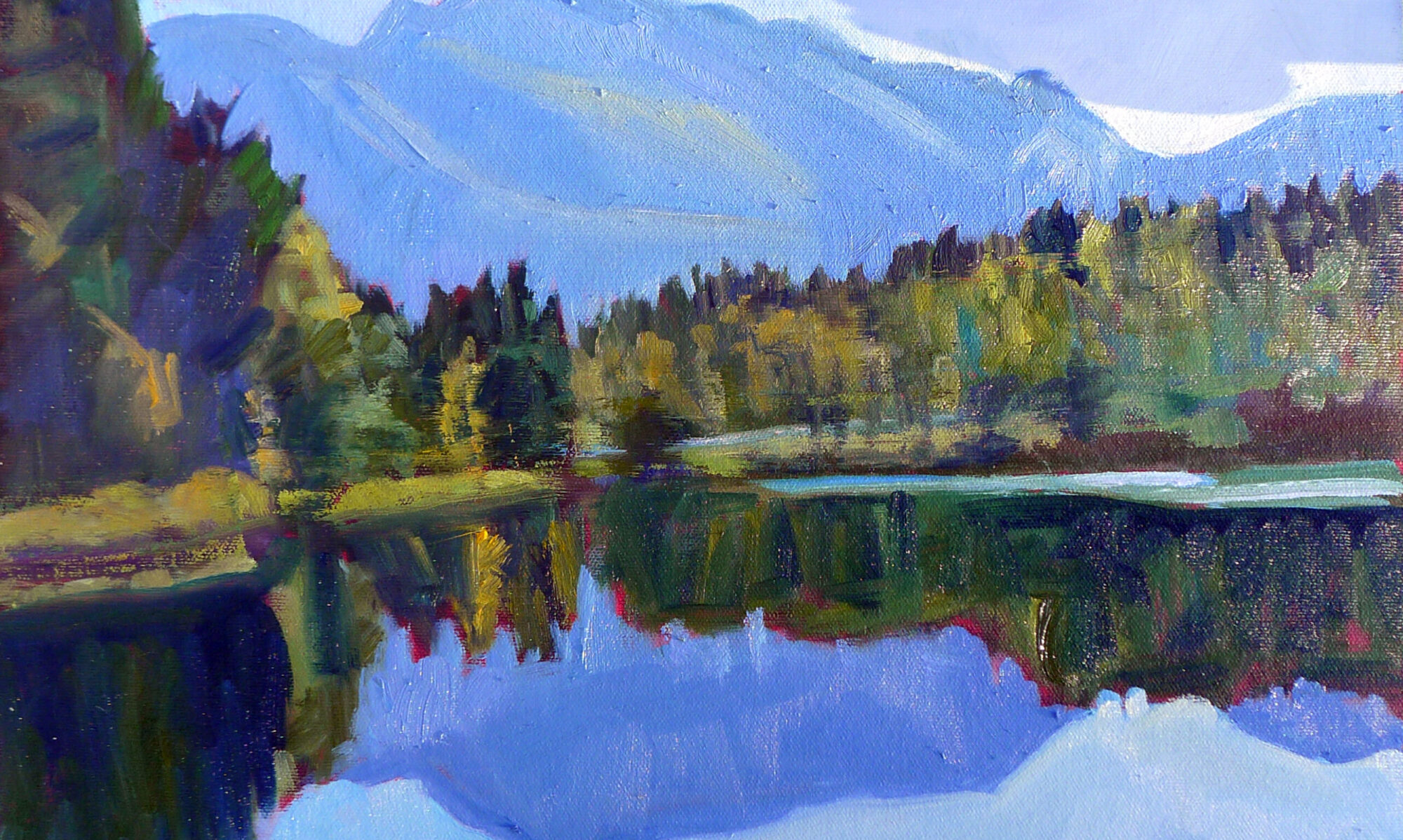
Manitoba is the geographical center of Canada and as such marks our halfway point. We began to see scrub oaks and willows along washes and riverbeds. The Assiniboine River wasn’t visible from the road, but it jitters around like the writing of a seismograph needle on the map. I pictured a gentle stream swishing back and forth in an old eroded channel.
At Brandon, we turned off the Trans-Canada and headed north on Route 10, looking for a place to paint. The landscape was suddenly looking very Midwestern. Farms replaced ranches, towns were more frequent, and the tree cover grew more abundant. Golden light poured down onto the newly mowed hayfields.
And then, with a mighty screech, the SUV powered down and refused to move. A turn of the key elicited nothing but a click. It could only be a failed alternator.
This is a view of our car that is getting tiresome.

This is a view of our car that is getting tiresome.
We sat and read silly novels on the roadside while we waited for the Canadian Automobile Association to send a tow-truck. Boy, am I grateful for their international reciprocity, as well as for global roaming on our cell phones.
Even in funny money, this is going to be costly, but at least it will be quick.
Scrub oaks along the Assiniboine River at Brandon, Manitoba. It looks a lot like the Erie Barge Canal.

Scrub oaks along the Assiniboine River at Brandon, Manitoba. It looks a lot like the Erie Barge Canal.
In the meantime, I have a loaner. I drove down to the Assiniboine River. It looked like the Erie Barge Canal.
I’ve gotten my day off, and this is forcing me to take the time to do our laundry. Then forward, and even if I’m cruising through Winnipeg at game time, I refuse to stop and watch the Blue Bombers.

Painting yesterday’s landscape

"Windbreak," by Carol L. Douglas.

“Windbreak,” by Carol L. Douglas.
We’ve traveled 4200 miles playing the game of “those cows are my cows.” (In our family, a herd of cows counts as one, a cemetery kills your opponent’s cows, and a church resurrects them.) Yesterday’s game was particularly cut-throat. It reminded me that I need an eye exam when I get home.
Since we can’t take it through a car wash, the SUV is looking downright geological. The arctic mud has eroded, and a fresh coating of Saskatchewan dust covers everything. A license plate bolt jarred loose and our Maine plate hangs at a rakish angle.
The only company we had while painting the windbreak.

The only company we had while painting the windbreak.
Our current path crossed last year’s at Regina, Saskatchewan. In this area, farms are still being worked, but the old prairie homesteads are abandoned. They are elegiac, and I’ve wanted to paint one since I first saw them.
I saw several on Tuesday, when the wind blew too hard to paint. Because I knew there were some in the Regina area, Mary and I dropped off the Trans-Canada Highway onto local roads.
Mr. Gordon Kish, ghost town owner.

Mr. Gordon Kish, ghost town owner.
From the place names, we realized Saskatchewan has a significant population of French-Canadians, or Fransaskois.
In 1752 Louis de La Corne led an expedition along the northern coast of Lake Superior, through Le Pas, Manitoba and to the forks of the Saskatchewan River. These lands became the most western in the French New World Empire. French fur traders roamed the territory for the following century, establishing families with native women. These people, the Métis Nation, developed a creole language called Michif, which is a complex blend of Cree and French. Later, French immigration into the area was actively encouraged by Canada.
Neelby's forgotten rail line.

Neelby’s forgotten rail line.
Stubbornly, our route refused to yield any abandoned houses. I decided to paint a windbreak instead. These stately lines of poplars seem curiously formal for the open prairie, but they are hardy and fast-growing.
I sat on a range road for several hours wrestling with the emptiness. I’m not thrilled with my solution. Thinking conventionally, I created foreground interest that’s, simply, a lie. It makes the space seem eastern and small. The painting needs editing, and I’m debating how to do it.
Unfinished painting of Neelby grain elevators.

Unfinished painting of Neelby grain elevators.
I find that as I enter new terrain, I stubbornly see it as a continuation of the prior environment, so gradual is the change. Saskatchewan is flatter and wetter than Alberta. Finally, I stopped and looked at what was actually there. Two abandoned grain elevators in the far distance caught Mary’s eye, and we lurched along a range road to get to them. There was one hour until sunset; I could do a small painting if I concentrated.
A truck pulled up. Gordon Kish, rancher and auctioneer, is the last remaining resident of the ghost town of Neelby, Saskatchewan. In fact, he owns all 220 building lots. Settled in the early 20th century, Neelby had a railroad line and a grain depot, but nearby Kipling was more visionary. It built a reservoir and piped water to the rail line. That made it more useful for steam engines. Neelby faded and died.
Thursday 1

The sun set as we left Neelby forever.
The sun faded as Mr. Kish and I chatted. I was tempted to camp in Kipling and spend another day in Neelby, but I realized I must move on. I have enough information to finish in the studio, however.

I’m not lost

"Coal seam," very unfinished. It's destined for the studio.

“Coal seam,” very unfinished. It’s destined for the studio.
“We are on the fringe of the great North and its living whiteness, its loneliness and replenishment, its resignations and release, tis call and answer, its cleansing rhythms. It seems that the top of the continent is a source of spiritual flow that will ever shed clarity into the growing race of America.” (Lawren S. Harris, 1926)
I was born exactly 144 km from Lawren Harris’ birthplace, and I understand the call of the Great White North as much as Tom Thomson and the Group of Sevendid. Still, I don’t think the Great White North is the beating heart of Canada. That honor must go to its prairies. Immense, they have a deep, diverse economy: oil, natural gas, coal, beef, grain, and wind. Once you’re away from the settlements, they are a land of enormous skies and great emptiness.
Even with easel lashed to SUV, the vibrations made it impossible to paint.

Even with easel lashed to SUV, the vibrations made it impossible to paint.
There are pumping jacks everywhere in eastern Alberta, and they were, in the majority, stilled. Canadian oil is in a bust phase of its boom-bust economy. Still, I wish we would buy whatever oil we cannot produce ourselves from our democratic neighbor to the north rather than from those who wish to harm us.
Atlas #3 coal mine on the Red Deer River.

Atlas #3 coal mine on the Red Deer River.
We set off yesterday to see Canada’s Badlands, promised hoodoos and dinosaur bones by Alberta Provincial Parks. Canada’s badlands are, like its people: nice. They are incapable of raising a frisson of fear. Still, the Red Deer River Valley is particularly lovely, with its fringe of trees golden against the scoured ridges.
Once again, I was flummoxed by the wind. The enormous windmills were making one revolution every three seconds. Parked in the shadow of a cliff, I lashed my tripod to the SUV, and set about painting a small study of a coal seam in the rock. The easel jarred and rattled even with many rocks weighing its base. My medium cup kept flipping over, so I put a pebble in it.
Going about the business of the plains.

Going about the business of the plains.
I wear a ponytail so that my cap doesn’t fly off, but even with that I was wishing for a string to hold it down. An hour later, I’d made very little progress. This painting is destined to be finished in the studio.
Our detour had taken us about 70 miles west, and it was midafternoon before we set off to our second destination: the Great Sand Hills of Saskatchewan. Northwest of the Red Deer River, the land is a little drier and wilder. There is more pasturage and less wheat. The wind ruffles grass the color of a Belgian’s hair in a motion that looks just like whitecaps on Penobscot Bay.
Pronghorn antelope notice our presence.

Pronghorn antelope notice our presence.
The internet is a little vague about how to reach the sand hills themselves, but we had an idea of where they were located, and I’m an inveterate shunpiker. Twice we set out along range roads and tracks in the general direction; twice we were rebuffed when the roads petered out into farm tracks.
That was a costly error.

That was a costly error.
It was not a wasted trip. A coyote loped across the road in front of us. Innumerable waterfowl filled the sloughs. Hawks, magpies and crows perched on fenceposts, waggling as they adjusted their weight to the wind. Herds of prong-horn antelope, startled by our approach, raced away across the prairie.
Prairie cemetery.

Prairie cemetery.
As the sun dropped, we quit our search and headed southeast to Swift Current. The well-head lights shone like fairy lights against the deepening blue twilight.
Today we have vowed to stay closer to the Trans-Canada Highway. All that shunpiking, while beautiful, was unproductive.

My life as a boulder

"Lake Moraine," oil on canvas, by Carol L. Douglas

“Lake Moraine,” oil on canvas, by Carol L. Douglas
I kicked us into gear absurdly early to make it to Lake Moraine before tourists mobbed the place. It was a futile effort; even as we scraped ice off the windshield, cars were winding up the road toward the two beautiful lakes.
We arrived to find a wedding party shooting what has become a popular photo: the ruination of a wedding gown. Slowly, they subsided into the frigid mountain water. Turns out it wasn’t their real garb and they were wearing wetsuits under their faux finery.

Tuesday 5
“If I did that, my mother would kill me,” Mary told a bystander. She’s right. My inner hausfrau is offended by the whiff of profligacy. I doubt the average couple thinks much about why it’s become a popular meme right now. However, prior generations encouraged their kids to “waste not, want not,” rather than trash the best clothes they’ll ever wear, even in effigy.
I’ve had many photos taken of me painting. I don’t mind being part of the scenery, but yesterday a Chinese tourist flummoxed me. “Do you mind if we take my picture with you?” she asked. In our native argot that means engaging with one another in the photo. After a few shots, I realized that she wanted me to continue painting stonily away while she cavorted around me making victory signs, as if I were a rock or a sign that read “Welcome to Moraine Lake.”
Painting at Lake Moraine, courtesy of Marvin Sodicoff.

Painting at Lake Moraine, courtesy of Marvin Sodicoff.
Marvin Sodicoff of Philadelphia took another picture and emailed it to me. It’s so nice I used it here. It shows a green cast to the water and the remarkable reflections on the lake surface.
"Mount Rundle," oil on canvas, by Carol L. Douglas

“Mount Rundle,” oil on canvas, by Carol L. Douglas
From Banff, we headed directly to Calgary for art supplies. Calgary was a great surprise to me. I’ve heard it referred to as “Cowtown,” but it is, in fact, a large, modern city sparkling in its western setting. Its contemporary architecture, particularly at the University of Calgary, is exceptionally lovely. I would like to return and explore it.
The beeves of the Great Prairie.

The beeves of the Great Prairie.
However, the Great Prairie was calling me. The golden evening light poured over pasturage, countless beeves, feed lots, oil derricks and small ponds filled with waterfowl.
We pulled up for gas at 6:30 PM and I realized I could go no farther. Today’s predicted high temperature is 75° F. Oh, bliss! I hope that baking in dry heat will cure what ails us. If not, we’ll have at least seen the world’s largest dinosaur.

The day my Superpower failed

"Confluence," oil on canvas, Carol L. Douglas

“Confluence,” oil on canvas, Carol L. Douglas
Every morning, I prod Mary until she pours herself into the car. She is still pretty low and would like nothing better than to sleep. I’m still wheezy myself, and it is hard to be the motive force in this campaign.
This morning, she realized she had left her wallet in Ft. Nelson after having her prescription filled. The clerk there couldn’t have been more agreeable, and will mail it along. However, Mary has no driver’s license. She’s been too sick to drive anyway, but I’d entertained fond hopes that she could take over before we hit Nova Scotia.
"Maligne Lake," oil on canvas, Carol L. Douglas

“Maligne Lake,” oil on canvas, Carol L. Douglas
On Friday night we drove to Miette Hot Springs, where I had a long dip while Mary rested. This is a beautifully situated spring, but its water is not particularly hot. Still, it was well worth the visit. It is at the northern end of the Jasper-Banff National Parks complex, making it the perfect jumping-off point for the weekend.
I painted in three locations on Saturday: along the Athabasca and Maligne Rivers, and at Maligne Lake. A lovely painting was around every corner, but three was my absolute limit.
"Maligne River," oil on canvas, Carol L. Douglas

“Maligne River,” oil on canvas, Carol L. Douglas
Jasper itself reminds me of Camden, albeit somewhat swollen. It has the same indecisive jaywalkers, but it is inauthentic, a hodgepodge of ersatz Alpine storefronts. I couldn’t tell if I was irritable at the crowds, at my own exhaustion, or at the crazy price inflation, but I was glad to leave.
We stopped at the Columbia Icefield. “This is the place,” I told Mary. The Athabasca Glacier tumbled off its mountain. Its glacial lake rested emerald green at its foot. We decided to walk to the toe of the glacier to reconnoiter.
We hiked to the toe of the glacier, but the wind was so strong my poor easel couldn't cope.

We hiked to the toe of the glacier, but the wind was so strong my poor easel couldn’t cope.
We were met by a ferocious, ripping wind. I was protected by several layers but nothing could stop my easel from spinning helplessly on its tripod, especially with no trees on which to tie it down. I tried parking the car as a windbreak; the wind swirled around it. Meanwhile, even in my airtight hood, my ears were ringing.
“It’s no good,” I told Mary. “I will have to paint it from a photo.”
We drove on.
There are certain beauty spots that I’m conflicted about, where the character of the place is obliterated by the masses of people. Yosemite is one of these; Lake Louise is another. I would have painted it, if only I could have approached it. Even now, at the end of September, both Lake Louise and Moraine Lake are packed solid with cars and people. It was impossible to park within a mile of either.
Cars lined the roads to both Lake Louise and Moraine Lake. There was no room for a poor itinerant painter.

Cars lined the roads to both Lake Louise and Moraine Lake. There was no room for a poor itinerant painter.
In general, Canadians are polite and friendly people. It seemed a pity to want to mow them down with my car, so I retreated to our hotel.
This morning I will try to get up there before the crowds return; if not, my series will be done without one of these iconic landmarks. Today we leave the Rocky Mountains behind us. The road we are now following is the Trans-Canada Highway, and it will take us safely across the prairies toward home.

Goodbye, Alaska Highway!

"Regrowth and regeneration," (Borrow Pit #4), by Carol L. Douglas

“Regrowth and regeneration,” (Borrow Pit #4), by Carol L. Douglas
Last summer it took us eight days to drive to Alaska in this vehicle. Given our detours and painting stops, doubling the time this year seemed a fair estimate.
Instead, we left the Alaska Highway at 4 PM yesterday.
East of Fort Nelson, Mary and I had to admit that not much looked familiar. True, we’d passed through here a month earlier last year. In fact, this was the same area in which we’d been stopped for hours due to an accident. But, no, we remembered nothing.
Getting out of here, even in 4WD, was tough. A sharp rise and a lip before we hit the road tore our tailpipe off.

Getting out of here, even in 4WD, was tough. A sharp rise tore our tailpipe loose.
Last year, this stretch seemed so desolate. Yesterday, it seemed sedate and settled. The Al-Can looks very different going west to east. Last year, we counted off the signs of civilization as we lost them: regular gasoline, rest stops, power lines, restaurants, and other travelers, until all that was left was us and the open road. This year, those same amenities crowd back into our vision like not-particularly-welcome relatives. I’ll be happy to be in my snug Maine house again, but I do like the solitude.
The Kiskatinaw Bridge is a three span, timber truss structure built in 1942 by the Corps of Engineers. It's still used today, and its maintenance must be a pip.

The Kiskatinaw Bridge is a curving, three-span, timber truss structure built in 1942 by the Corps of Engineers. It’s still in use today, and its maintenance must be a pip.
One great difference this year has been pavement. It’s mostly past construction season. There are not many sections gravier signs left to remind Mary of poutine. However, the fact that she could joke about poutine is a good sign, for it signals the return of some appetite, even though she still remains pretty low.
About 100 km east of Fort Nelson, I pulled down an off-road track to paint some regrowth in a wildfire area. This is a subject I’d like to return to, since the geometry and variety are so fascinating. But I never relaxed while doing the painting. Plein air painters know this feeling of unease. For me it’s very rare, so when it happens, I heed it. After all, I was standing in a black bear’s salad bowl. So this was a rushed effort, and I’ll detail it in the studio.
There are a few paintings that “got away” along the Al-Can. One was of a hunting camp along the highway. I’d hoped to find one on this last day to paint. I also wanted to paint something of the Peace River Valley, for it looks so western here in its deeply cut ravine.
Goodbye, Alaska Highway!

Goodbye, Alaska Highway!
Alas, the Al-Can carries much more traffic near its eastern terminus. There’s gas exploration, agriculture, and much logging. The shoulder is narrow and the lay-bys few and far between. I took a few tracks off the main road, and came up with nothing. That seemed ironic, since most of the trip has been filled with stunning vistas at every turn.
“It’s an early bedtime, then,” I told myself, and pushed on to our destination. There, Mary pointed out that I’d knocked the tailpipe off while off-road. So once again this morning will be spent in a muffler shop and we’ll be that much little bit more delayed.
I remind myself that we’ve just passed through more than a thousand miles of territory where there are no muffler shops. We have a choice of four here in Dawson Creek. My irritation melts into gratitude to a providential God.

On the edge of civilization

"McDonald Creek," by Carol L. Douglas

“McDonald Creek,” by Carol L. Douglas
I’ve seen Mary’s headache, malaise, and swollen neck before. Her older sister had mononucleosis in college and looked and acted the same way. When Mary’s tonsils started to swell, I decided to make quick time to a medical clinic at Ft. Nelson, BC.
Three minutes and $70 later, Mary exited with a scrip for penicillin. No blood tests, no swabs; the doctor took a quick look in her mouth and announced it was tonsillitis. Penicillin won’t hurt the girl and might actually help, so we had it filled. Mono is untreatable anyway.
Mary took a nap in the sun while I painted.

Mary took a nap in the sun while I painted.
My husband asked why I didn’t see the doctor myself, since I’m still hacking. I just have a cold, I answered. For less than the cost of penicillin, I can rinse my mouth with Alberta rye whiskey. If it doesn’t cure me, at least I won’t mind so much.
Fort Nelson is on the east slope of the Rockies. It seems positively cosmopolitan compared to where we’ve been. Some women have tri-colored highlights in their hair, all in the same gingery tones. That, I presume, implies a beautician in town. There is clothing other than camouflage, although the Super 8 where we’re staying does have a sign asking visitors to remove their muddy boots.
Trail riders are a common site in northern British Columbia.

Trail riders are a common site in northern British Columbia.
Hayfields and buildings appear sporadically along the road into town. The tree cover looks more familiar to my eastern eyes. Mixed forests of predominantly deciduous trees cover the lower slopes.
Today we will follow the Alaska Highway to its starting point at Dawson Creek. This will take us down into the prairie land of Peace River Country. This area was explored during Sir Alexander MacKenzie’s journeys of 1789 and 1792-3. The latter was the first east-west crossing of North America north of Mexico, preceding the Lewis and Clark expedition by 10 years.
Like so many great American explorers, MacKenzie’s goal was to find a water route across the continent—the fabled Northwest Passage that beguiled the Vikings, Cortés, Sir Francis Drake, John Cabot, Henry Hudson, LaSalle, and so many others. MacKenzie, however, managed to reach all three great oceans that surround Canada, and his explorations took him on the longest possible route, for the continent grows wider as it goes north.
My main companions yesterday were bears, not hoofed things. It's almost time to hibernate.

My main companions yesterday were bears, not hoofed things. It’s almost time to hibernate.
Our prairie time will be briefly interrupted with a slight detour into Banff and Jasper National Parks this weekend. After that, I’m hoping to make better time. A flatter road will be nicer on the old hooptie, which seems to have sprung another exhaust leak. Poor old thing. I’m not sure who’s suffering more, the car or Mary. I’ll push the liquids at both of them.

Twice told tales

"Avalanche Country," oil on canvas by Carol L. Douglas.

“Avalanche Country,” oil on canvas by Carol L. Douglas.
Mary is flat on her back, ill with something I cannot figure out. I have a nasty cold; she has that and something else. I left her sleeping in a room at the Toad River Lodge and headed back to Muncho Lake to paint.
Northwest Canada and Alaska rivers and lakes are often strangely-colored—milk chocolate brown, ivory, or turquoise. This is caused by rock flour, which is a substance of fine-grained particles of rock ground off bedrock by glacial erosion. Because the silt is so fine, it ends up suspended in glacial meltwater, creating cloudy water sometimes called glacial milk.
These fellows came to visit me while I was painting. When they realized there was a human involved, they skedaddled. There was a foal with them, who stayed carefully behind. I'm ashamed to say I have no idea what species they are.

These fellows came to visit me while I was painting. When they realized there was a human involved, they skedaddled. There was a baby with them, who stayed carefully behind. I’m ashamed to say I have no idea what species they are.
Lake Louise in Alberta is the most famous of these rock flour lakes, but they occur anywhere there’s glaciation. West of Toad River there are great dumps of till that look for all the world like glacial moraines. We haven’t seen a true glacier in hundreds of miles, but there are permanent snow caps here.
Mary’s illness gave me the opportunity to paint rock-flour water. Muncho Lake is about 50 km west of Toad River community, so I backtracked there, first to paint the Toad River along an avalanche path, then to paint the lake itself in the afternoon sun.
"Muncho Lake," by Carol L. Douglas.

“Muncho Lake,” by Carol L. Douglas.
The Toad was named for the enormous toads found there by Hudson’s Bay Company explorers.  “I have seen some which weighed upwards of a pound, and the Indians inform me there are some to be seen of a much larger size,” wrote John McLeod in 1831.
It is so much easier to paint something commonplace than something unusual. Get the general shape of a teapot and your viewers will understand it to be a teapot. Hit the color of rock-flour water almost perfectly and it looks absurd.
The Toad River Valley is full of glacial till.

The Toad River Valley is full of glacial till.
I’ve thought a great deal about Tom ThomsonEmily Carr and the Group of Seven painters while on this trip. There is something fantastical about their paintings that the American viewer sees as romanticism, or, to put it bluntly, exaggeration for effect. In fact, it turns out to be literal truth-telling. Thomson’s famous Jack Pine may be stylized, but it’s also a tremendously accurate drawing, particularly of the squat black mountains in the background.
Can a viewer in the east understand that a western black spruce might rise like a stick in the air and sends out a bulb of branches at its tip, oddly reminiscent of a fiddlehead fern? Or that some wildfires kill, and other wildfires seem to simply prune, the trees sending out shoots from their blackened trunks?
One too many inquiries.

One too many inquiries.
If you see struggle in these two paintings, you’re looking at them correctly. The colors here are so otherworldly that I’m having trouble committing them to canvas.
I returned to Toad River in the early evening to find that Mary still hadn’t stirred. At this point, my husband took over as long-distance logistician. He has us moving in slow stages over the next few days so that she can rest and recover—and above all, not camp. I’m alright with that, since the temperatures in Jasper and Banff National Parks are well below freezing at night. Even better, there is a clinic in Fort Nelson, and one at Dawson City. If she isn’t perkier today, she’s going to see a doctor.

Little bear

"Tamarack bog," by Carol L. Douglas

“Tamarack bog,” by Carol L. Douglas
While painting the bogs along the boardwalk to Liard Hot Springs in British Columbia, I was interrupted by a park vehicle that needed to pass. The driver and I peered at each other and realized we’d met last year. He’d given us a ride back from the hot springs in the middle of the night, stopping to check for bears frequently along the way.
“Good thing he did,” his brother told me. In 1997, a bear attacked four people at the hot springs. Two died and two were horrifically injured before the animal was shot. The park remains a hot-spot for bear-human interaction, and this year was particularly hard. When the blueberries are bad, the bears come down the mountain and enter the human areas of the park. The average tourist is clueless about bears, as I was reminded when I saw them exiting their cars to take photos of bears on the side of the road.

A black bear looking for clover in the Liard River Basin. “Bears are like hairy pigs,” a naturalist told me. “They’ll eat anything.”
These are not our eastern black bears. “People tell me that they saw a ‘little’ bear,” the park worker told me, “and when they’re trapped they turn out to be 350 pounds. That’s 350 pounds of muscles, claws and teeth.”
Right now, they have the bears pretty well cleared out of the area, but they’ll inevitably be back. The park is full of warning signs about them (“A fed bear is a dead bear”) and instructions on what to do if you encounter one.
The Liard River basin is known for its wandering herds of bison. They own the road, and this big bull was disinclined to let us pass.

The Liard River basin is known for its wandering herds of bison. They own the road, and this big bull was disinclined to let us pass.
The brothers are busy with chainsaws and weed-whackers, cutting the brush back from the boardwalk. That cuts down on surprise encounters.
Even though this is by far the best hot spring I’ve ever visited, I’ll never walk down to it in the middle of the night again. And in fact I didn’t visit it yesterday, either. Instead, I set up on the boardwalk to paint the tamaracks turning color along the bog.
Tamaracks, or larches, are deciduous conifers. They shed their needles in the fall.

Tamaracks, or larches, are deciduous conifers. They shed their needles in the fall.
In the east, we call this tree a larch; either name is correct. Although conifers, larches are also deciduous, meaning they lose their needles in autumn. I’ve been watching the spruces give way to them as we’ve traveled east. Their yellow is a more delicate color than the blazing golds of birch and aspen.
Watson Lake's signpost forest was started in 1942 and now has over 70,000 signs from all over the world.

West of Liard River is Watson Lake. Its signpost forest was started in 1942 and now has over 70,000 signs from all over the world.
There are two more subjects in this part of the world I’d like to capture. One is the vastness of wildfire; the other is the color of water containing rock flour. Being ill, I haven’t done justice to this part of the trip. So I plan to backtrack today, toward Muncho Lake and the fast-moving waters of the Toad River.
"Clouds over Teslin Lake," by Carol L. Douglas. The atmospheric perspective here is very different from the east.

“Clouds over Teslin Lake,” by Carol L. Douglas. The atmospheric perspective here is very different from the east.
Teslin is an Inland Tlingit community on the edge of Nisutlin Bay on Teslin Lake, Yukon. It is, in fact, one of the largest native populations anywhere in the Yukon. We’d stopped here for gas on our last trip and noticed the beautiful traditional murals on public buildings. So we were happy to stop for a warm meal and gasoline at the Yukon Motel.
In the ladies’ room, a young woman was anxiously asking about campsites and routes to Seattle. I realized she was traveling alone and did my best to assuage her concerns. Mary asked her why she didn’t head south to Haines and take the ferry.
“I can’t afford it,” she said. “My friends collected $100 for me before I left and that’s all the money I have. I’ll be OK, really.” She was driving a small hybrid but $100 was pretty slim to get her from Alaska to Seattle, even camping and eating out of her car.
Casualty of the trip: my compass is dead.

Casualty of the trip: my compass is dead.
At that, another woman pulled out some American currency and pressed it in her hand. “No!” the young woman exclaimed. “I’m all right, really.”
“If I had a daughter traveling like this, I’d want to know that she was being helped by strangers,” said the woman. At that the young woman enveloped her in a hug.
Her car and clothing were too new for her to be a backroads adventurer. I didn’t know what she was running from or to, but it pushed her to drive this road alone, on the edge of snow season, with insufficient resources.
"Princess Street, Dawson City, Yukon.

“Princess Street, Dawson City, Yukon.
Earlier, at Dawson City, we’d met a man walking across Canada. Dana Meise is a forester from British Columbia and his goal is to hike to all three of Canada’s oceans. He started in Cape Spear, Newfoundland and intends to end at Tuktoyaktuk, Northwest Territories.
Dana was stalled in Dawson City because his tent fly had been damaged and needed to be replaced; then he was heading north up the Dempster Highway to the Arctic. That last 800 miles is the end of his nine-year sojourn. Having just left the Arctic Circle ourselves, we knew it was snowing. “Oh, that doesn’t bother me,” he said. “I’m a forester; I’m prepared.”
We camped at Teslin Lake on Saturday night. Our only neighbor was another woman traveling with a child.
We've been dogged by cold rain every day. It's not helping our sinuses.

We’ve been dogged by cold rain every day. It’s not helping our sinuses.
There is something about this land that brings out self-reliance, or perhaps it attracts the self-reliant. There is also a culture of the Al-Can that starts to grow on you as you wander here and there. “He’s kind of crabby, but he’s a great guy—a real Alaska Highway character,” a parks employee described a lodge-keeper I would encounter a hundred miles or so down the pike. There are young people who’ve escaped from more civilized places, and grizzled old-timers who take your money without a word, and truck drivers who make sure you have enough petrol to make the next services.
Mary and I are both still quite ill. It’s cutting into our progress. I’ve got one painting and a few hundred miles per day in me right now, and I’m so concerned about all the paintings that have gotten away. But the truth is, I could spend the rest of my life painting the Al-Can and not exhaust the material, so I can’t let it bother me.